Projects & Media
AI-Driven Assessment of U.S. Inland Flood Inundation at High Resolution across the 21st Century
2026-2028 NSF NCAR EdEC Faculty Innovator Program Cohort 4 Co-Is Andy Newman, Andy Wood, James Done, DJ Gagne, Samar Minallah, Seth Bryant, Saurabh Kaushik, Dan Wright, Alex Saunders
First, we will advance science for predicting inland flood hazards by bridging the gap between coarse-resolution global climate drivers (CMIP6) and high-resolution local inundation. Local inundation observations will be derived from high-resolution satellite data (3m-250m) from the NSF EAGER project, to produce US Flood Extents Database. This advances prior convolutional neural network (CNN)-based approaches by leveraging NSF NCAR’s Community Research Earth Digital Intelligence Twin (CREDIT), which employs a SwinTransformer. Second, we will produce an open-access ensemble of daily flood hazard projections from 1950-2099. From this time series, we derive 10-, 20-, and 50-year return period maps at 30 m resolution, aligned with common engineering design lifespans. The work is focused on the Rio Grande and Mississippi River basins
Satellite-Based Evaluation of U.S. Flood-Mitigation Infrastructure Performance
2025-2027 NSF EAGER (#2535036) Co-Is Seth Bryant, Saurabh Kaushik, Jon Sullivan
Current regulatory floodplain maps from FEMA underrepresent flood risk,
which most research assumes is due to failure to produce or update maps,
or incorporate different flood causes. Yet, the “undermapping” of flood risk could also be due to reductions
in regulatory floodplains from real estate developers who can demonstrate
they decreased the floodplain with mitigation infrastructure
through the Letters of Map Revision (LOMR) policy. Where is flood mitigation infrastructure effective at reducing
flooding in the US and where do new opportunities for strategic investment exist?
This project will analyze where FEMA flood maps have been reduced due to
LOMR policies and build a spatial database of flood events from multiple satellite observations
from 2001-2025 in the US using machine learning to evaluate these questions.
Read more: “The New Gerrymander: Flood Maps” — The Commons, Nelson Institute
Flood Justice Fellows
2026-2027 Morgridge Community Based Learning Grant, Reilly-Baldwin Wisconsin Idea Seed Grant, and the Brittingham Wisconsin Trust
We are currently piloting the Flood Justice Fellows program, a capacity building intiative with community-based organizations in Wisconsin to expand organizations' ability to produce and analyze satellite-based flood exposure maps. Throughout the program, representatives from organizations will collaborate with the Social Pixel Lab and students at the University of Wisconsin-Madison in the community-based learning course, Applied Flood Exposure, Vulnerability, and Adaptation to complete a semester-long project addressing a flood data gap in fellows home regions.
Community-Based Flood Engagement in Wisconsin
2026-2027 Reilly-Baldwin Wisconsin Idea Seed Grant
We are currently doing outreach with flood-focused organizations throughout Wisconsin in developing long-term partnerships and pursuing grant writing opportunities at UW Madison, NASA, and additional foundations as directed by partner organizations to address community needs related to flood resilience.
Grant Terminations
Two of our NSF grants were terminated after DOGE started eliminating federal contracts at NSF and we were given this reason. "NSF is issuing this termination to protect the interests of the government pursuant to NSF Grant General Conditions (GC-1) term and condition entitled 'Termination and Enforcement,' on the basis that they no longer effectuate the program goals or agency priorities. This is the final agency decision and not subject to appeal." We have appealed the NSF CAREER termination via University of Arizona but no response was received. ASU did not appeal the RCN termination.
Catalyzing Flood Justice in the US
TERMINATED 4/25: NSF Research Coordination Network
This Research Coordination Network (RCN) addresses the urgent issue of flood injustice by examining the social, economic, and environmental factors that contribute to unequal flood risks and recovery outcomes. Communities of color and those of low socioeconomic status are often disproportionately affected by flooding due to historical inequities and inadequate infrastructure. This project aims to bring together researchers, policymakers, and community organizations to identify and address flood injustice through collaborative research and action. By focusing on interactions between the built environment, natural systems, and social vulnerability, the project seeks to inform public policy and create more equitable flood management strategies, benefiting communities nationwide. It also aims to enhance public understanding of flood risks and empower communities through education and engagement by creating educational opportunities and collaboration among students, researchers, and community members. Read more here
Addressing flood justice and equity impacts of adaptation and urban expansion with satellite observations
TERMINATED 4/18: NSF CAREER Award
To expand urban development, preserve property values, or avoid paying for flood insurance, real estate developers in the US may request to remove properties from the Federal Emergency Management Agency (FEMA) regulatory floodplain, often by building flood mitigation infrastructure like levees and improved drainage. However, this flood mitigation infrastructure could be draining floodwaters to others downstream, an effect has not been measured. This Faculty Early Career Development CAREER project will advance knowledge by generating observed flood data to measure if and where flood mitigation infrastructure changes flooding and who is affected. The project will build capacity for environmental justice organizations to use satellite-based flood maps to challenge changes to FEMA flood maps and advocate for adaptation funding for their communities. Read more here
FLUJOS: Flood Justice using Satellite Imagery - Rio Grande Valley
2023–2024 | Google Environmental Justice Data Fund (Award: $139,647) & Climate Change AI & U Arizona Community Engagement Grant. With Texas Rio Grande Legal Aid, Lucas Belury, Zhijie Zhang
This project will leverage satellite-based flood maps in four Rio Grande Valley (RGV) counties (Willacy, Cameron, Hidalgo and Starr) to co-produce a data tool, designed and evaluated by local community-based organizations, in one of the most flood vulnerable regions of the US. We will: i) build an open access history of satellite-observed inundation in the RGV, ii) advance legal advocacy opportunities by identifying disparate impact, inverse condemnation, or discriminatory intent in flood patterns and infrastructure, iii) overlay satellite-based flood maps with the service areas of existing community-based organizations to identify currently unknown flood vulnerable areas or populations and, iv) co-develop, build, and evaluate a prototype data tool to further flood justice in the RGV. To build a library of flood maps, we will use machine learning approaches to extract surface water imagery from five satellites (Landsat 8, Sentinel-1, Sentinel-2, MODIS, and PlanetScope) at various resolutions. The maps will be assessed and ground truthed in field visits and community workshops to improve existing algorithms and assess the limits of satellite-based flood data in this region. The ultimate tool and the data created will be made publicly available. See the completed data and tool here.
Selected media:
Seeking Flood Justice in the Rio Grande Valley The Border Chronicle
2022-2023 International Working Group to Assess Flood Recovery, Adaptation, and Resilience from Space
2022–2023 | Arizona Institute for Resilient Environment and Societies. Led by Hannah Friedrich
 The working group assembled a network of scientists and practitioners to
develop a conceptual framework and research agenda for using satellite imagery to
monitor flood resilience, adaptation, and recovery.
This working group unified flood researchers and practitioners to achieve three
outcomes to foster innovation in measuring flood recovery and adaptation from satellites. We organized a workshop at the Global Flood Partnership 2022 meeting
and the public 2023 Flood Justice Symposium at University of Arizona. A recording of that event is available
here.
We are currently exploring funding to keep the network alive!
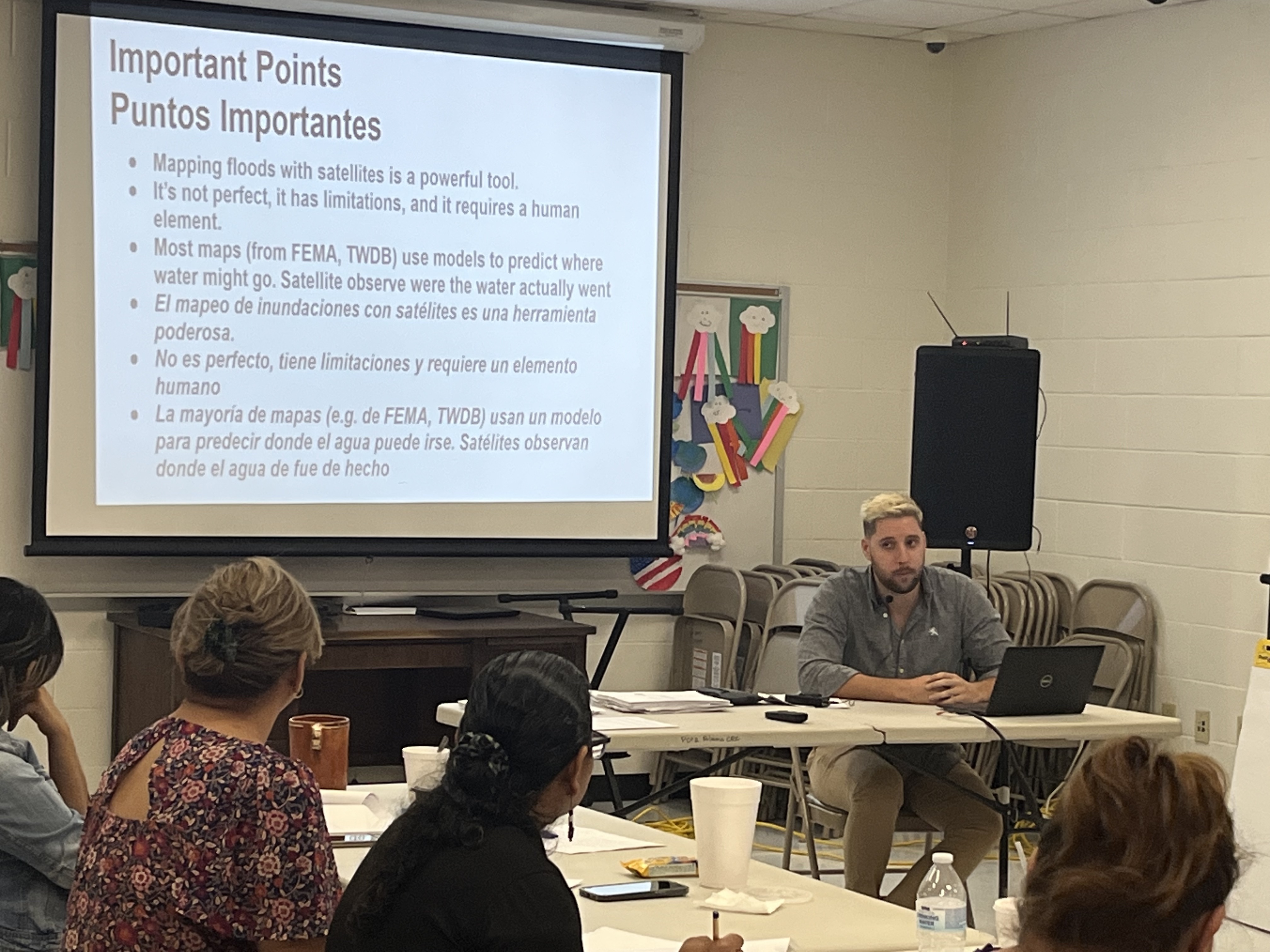
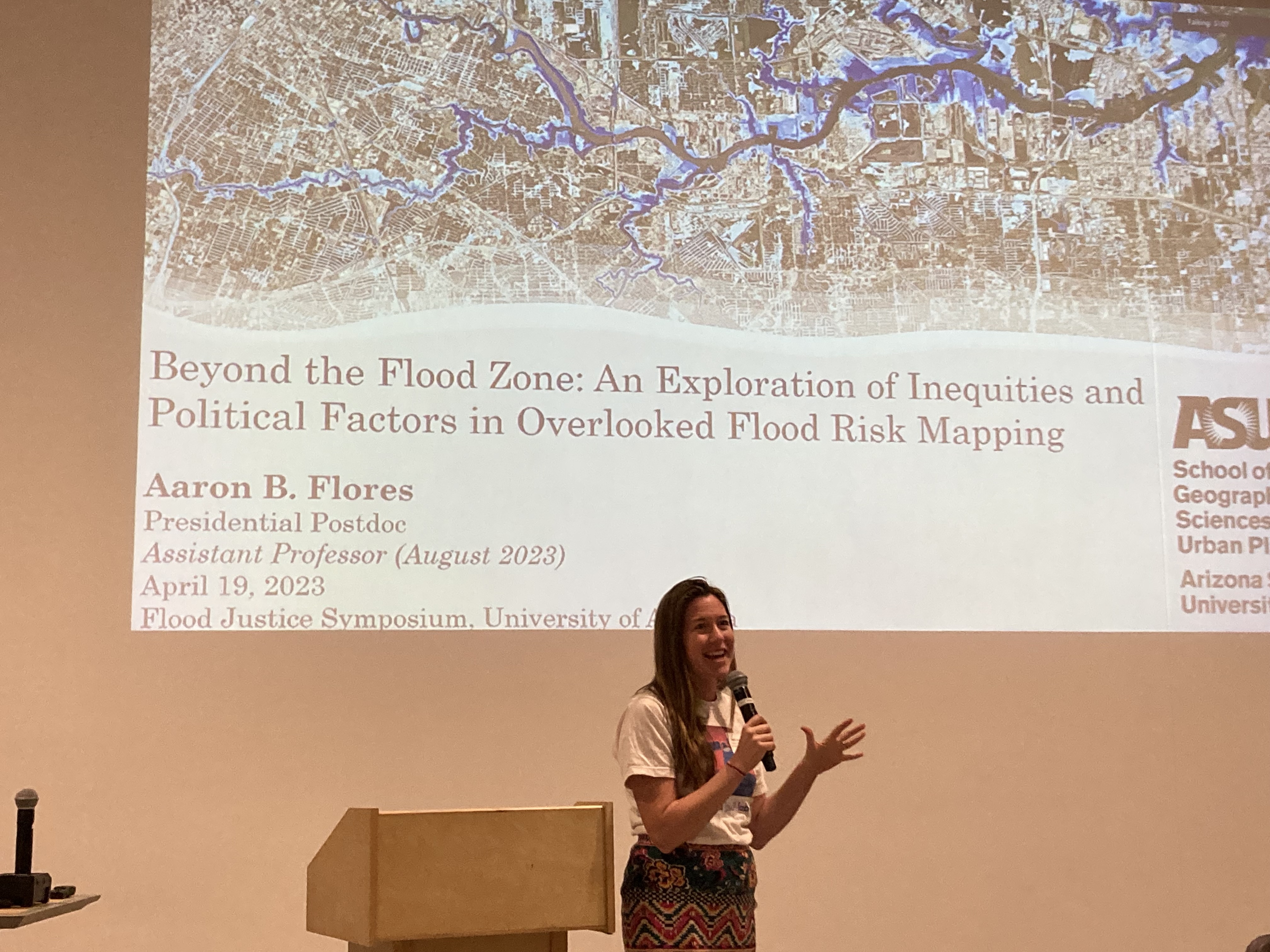
Flood Justice Symposium, University of Arizona, April 2023
The working group assembled a network of scientists and practitioners to
develop a conceptual framework and research agenda for using satellite imagery to
monitor flood resilience, adaptation, and recovery.
This working group unified flood researchers and practitioners to achieve three
outcomes to foster innovation in measuring flood recovery and adaptation from satellites. We organized a workshop at the Global Flood Partnership 2022 meeting
and the public 2023 Flood Justice Symposium at University of Arizona. A recording of that event is available
here.
We are currently exploring funding to keep the network alive!
Flood Justice Symposium, University of Arizona, April 2023
Key papers:
Earth Observation to Address Inequities in Post-Flood Recovery
Five Key Needs for Addressing Flood Injustice
Enhancing the Evidence for Humanitarian Action (EEHA) in the Face of Climate Change
2022–2025 | USAID Bureau of Humanitarian Affairs (BHA). Total Award: $995,514; Lab Portion: $169,797. PI: Zack Guido. Co-I Tellman, Mukherjee, and Sharma from Social Pixel Lab.
The Enhancing Evidence for Humanitarian Action (EEHA) will identify, develop, and test novel indicators and methods for measuring the results and effectiveness of humanitarian investments in three sub-sets of USAID DRR and related programming; local early warning systems, DRR governance (action, contingency, and response planning), and diversified livelihood strategies that reduce disaster risk and enable households and communities to adapt and become more resilient to climate variability and change.
Key papers:
Humanitarian Assistance and its Expected Behavior and Land Use Changes: Insights from Bangladesh and Kenya. Diana et al. incl. Prashanti Sharma. International Journal of Disaster Risk Reduction, 2026.
Feasibility of Satellite Based Flood Extent Monitoring in Pima County
2022 | Pima County Flood Control District. Award Amount: $28,303
This project explored different satellite data sources and modeling techniques in order to assess the potential for remote sensing of monsoon flood events for Pima County.
NASA funded flood mapping efforts
2021–2023 | NASA Commercial SmallSat Data Analysis. Award #80NSSC21K1163. Total Award: $199,861; Lab Portion: $119,847. PI with collaborators Iskha Gurung, Andrew Molthan (NASA), Kobus Barnard, and Upmanu Lall. High-resolution imagery to train and validate deep learning models of inundation extent for multiple satellite sensors
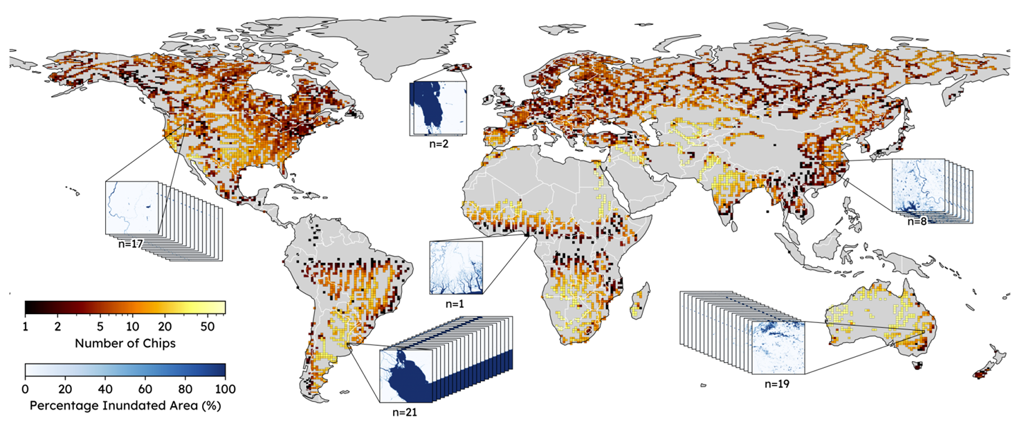
Our dataset, called FloodPlanet, will include 25 major flood events, labeled with co-located Planet, Maxar, HLS (Harmonized Sentinel-2 and Landsat), and Sentinel-1 data to promote cross-sensor fusion across public and commercial sensors and deep learning modeling efforts in the remote sensing and computer vision fields. We will develop our own deep learning models for high-resolution urban flood detection, and release the high-quality benchmark dataset we will produce in this proposal. As an extension of this project, we are also testing the potential for water mapping with the commercial Black Sky satellite
Key papers:
2021–2024 | NASA Terrestrial Hydrology. Award #80NSSC21K1341. Total Award: $660,360; Lab Portion: $555,157. PI with Co-Is Upmanu Lall, Pierre Gentine, and Venkat Lakshmi. Mapping flood impacts using multi-sensor satellite data fusion in urban areas
In this research, we are developing novel sensor fusion techniques to take advantage of the expanding availability of sensors with different spatial and temporal resolutions to monitor urban flooding. To do so, we combine public optical (MODIS, Landsat, Sentinel-2), radar (Sentinel-1), passive microwave (AMSR, SMAP) imagery and commercial data from PlanetScope with the eventual goal of generating 30-meter per-pixel probabilities of inundation in urban areas globally every 3 days.
2022–2024 | NASA Hydrology Lab. Award #80NSSC22K0744. Award Amount: $120,000. Validation and machine learning approaches for surface water mapping with PlanetScope.
This collaboration with Fritz Policelli aims to develop a benchmark dataset for surface water detection sampling a diversity of rivers around the world and labeling water using PlanetScope. All images are co-located with Sentinel-1 imagery to validate Dr. Policelli's Gaussian distribution approach to Sentinel-1 water mapping aimed at extracting river widths over time. The labeled dataset is available here
Key papers:
2023–2025 | NASA Hydrology Lab ACCESS. Award #80NSSC23K1415. Award Amount: $214,113.
 We developed VIIRS ML-FWD (Machine Learning Fractional Water Detection), a deep learning global inundation algorithm estimating fractional flooded area at 375-m resolution. Trained on 86,000+ water observations from Sentinel-2 Dynamic World, it outperforms NASA and NOAA's existing VIIRS models by 141% and 35% (relative R²) across 6.8 million km² and 100 flood events globally. Public deployment via NASA's LANCE system is planned for late 2026 — marking the first machine learning-based operational flood product at NASA with global daily coverage. Led by PhD student Alex Saunders. See Alex's talk at the Global Flood Partnership 2026 webinar series.
Flood Mapping and Insurance in Bangladesh
2021–2024 | NASA New Early Career Investigators Program Earth Sciences. Award #80NSSC21K1044. Award Amount: $377,733. PI with Collaborators Upmanu Lall, Saiful Islam, Mohammed Bhuyan, Mehadi Hasan, and Sarder Raihan. Understanding flood risk in human altered landscapes from cities to farms: inferences from satellites and machine learning, with initial funding from the Columbia University ActToday Program.
This project leverages inundation observations to understand extreme flood risk in human-modified landscapes, specifically in urban and agricultural areas in Bangladesh. We will use commercial and public sensors to i) map maximum inundated area for extreme flood events, ii) quantify flood risk at watershed scales, and iii) estimate flood return periods at household scales (30m resolution). These objectives will be reached by using deep learning approaches to map floods and damage, and estimate return periods with Bayesian Hierarchical Models. We will use optical and radar satellites, including MODIS, Sentinel-1, PlanetScope, and the HLS (Harmonized Landsat Sentinel-2 dataset), comparing satellite-based flood maps and return period predictions for Bangladesh to those produced by the Bangladesh Flood Forecasting and Warning Centre (from a physically-based model). In May 2023, we discussed applications for insurance and climate risk financing with collaborators in Bangladesh and ran a training on how to make a flood map in Google Earth Engine and with Machine Learning. Training materials from our 2 days course (code plus slides) are available here. We have developed a 500m weekly inundation data set for Bangladesh from 2001-2022 that fuses MODIS with Sentinel-1, see our datasets page for access.
Key papers:
A framework to assess remote sensing algorithms for satellite-based flood index insurance.
Regional Index Insurance using Satellite-based Fractional Flooded Area.
Sensitivity to Data Choice for Index-Based Flood Insurance. Alex Saunders et al. Earth's Future, 2025.
Selected media:
Understanding flood risk from space: opportunities to adapt to changing risk with improved monitoring at The University of Colorado, Boulder, Geography Colloquium; Mapping floods for insurance applications in Bangladesh at WKCR Radio Interview; Climate Insurance, (Mal)adaptation, delaying inevitable retreat or migration? 2021 Columbia Managed Retreat Session
Illicit activity and land change: Narcotrafficking in Central America
 Illicit economic activity shapes land use around the world, but inadequate data makes it difficult to quantify relationships. We've developed methods to leverage news media and satellite data to study how illicit activity shapes landscapes in Central America, the region where the vast majority of cocaine that arrives in the USA travels through. As the US war on drugs attempts to
(unsuccessfully) intercept drug traffickers, they move into remote forested regions. This arrival of drugs, and the capital that comes with it, causes changes in land cover, use, ownership, and control with adverse
impacts on people, forests, and biodiversity in Central America. In collaboration with a larger research team, we seek to better understand how narcotrafficking transforms landscapes and what policies could reduce violence and support sustainable development in the region. Funded 2021–2024 by NASA Land Cover Land Use Change (Award #80NSSC21K0297, $696,112 total; lab portion $135,663), PI: Nicholas Magliocca.
Illicit economic activity shapes land use around the world, but inadequate data makes it difficult to quantify relationships. We've developed methods to leverage news media and satellite data to study how illicit activity shapes landscapes in Central America, the region where the vast majority of cocaine that arrives in the USA travels through. As the US war on drugs attempts to
(unsuccessfully) intercept drug traffickers, they move into remote forested regions. This arrival of drugs, and the capital that comes with it, causes changes in land cover, use, ownership, and control with adverse
impacts on people, forests, and biodiversity in Central America. In collaboration with a larger research team, we seek to better understand how narcotrafficking transforms landscapes and what policies could reduce violence and support sustainable development in the region. Funded 2021–2024 by NASA Land Cover Land Use Change (Award #80NSSC21K0297, $696,112 total; lab portion $135,663), PI: Nicholas Magliocca.
Selected media:
To preserve tropical forests, empower local communities: Phys.org ; Los guardianes de la selva maya desafían a narcos e inversores: ElPais ; Beyond 'business-as-usual': using news media and satellites to connect drug trafficking to forest loss: Behind the paper, Nature Sustainability ; Paths to Sustaining Forests and Communities in Guatemala's Maya Reserve: Sustain What? podcast with Andy Revkin The impact of cocaine trafficking on tropical forests in Central America Reddit Science AMA (Ask Me Anything) ; Satellite analysis cited by Colombian President Gustavo Petro, including coverage on Canal UNO, in his meeting with Trump on the US War on Drugs (January 2026): see tweet
Key papers:
Illicit Drivers of Land Use Change: Narcotrafficking and Forest Loss in Central America
Understanding the role of illicit transactions in land-change dynamics
Narcotrafficking and Land Control in Guatemala and Honduras. Tellman et al. Journal of Illicit Economies and Development, 2021.
A Convergence Research Approach to Resolving ‘Wicked Problems’: Lessons from an Interdisciplinary Research Team in Land Use Science. Devine et al. incl. Tellman. Applied Geography, 2025.
A Data Pedigree System to Support Geospatial Analyses of Human-Environment Interactions in Data Poor Contexts. Magliocca et al. incl. Elise Arellano-Thompson & Beth Tellman. International Journal of Geographical Information Science, 2024.
Informal urbanization: Mexico City
 Urban expansion is growing fast in the Global South, much of which occurred on land unplanned for formal urban development.
Informal urban settlements provide needed housing for growing populations, with subsequent needs for services like water, electricity, and property titles.
We've been studying what (and who!) governs informal urban expansion in Mexico City, and the social and environmental consequences.
Urban expansion is growing fast in the Global South, much of which occurred on land unplanned for formal urban development.
Informal urban settlements provide needed housing for growing populations, with subsequent needs for services like water, electricity, and property titles.
We've been studying what (and who!) governs informal urban expansion in Mexico City, and the social and environmental consequences.
Key papers:
Electoral politics influence expansion and titling of informal urban settlements. Tellman et al. PNAS, 2026.
Infrastructure, water vulnerability, and adaptation: Rainwater Harvesting in Mexico City
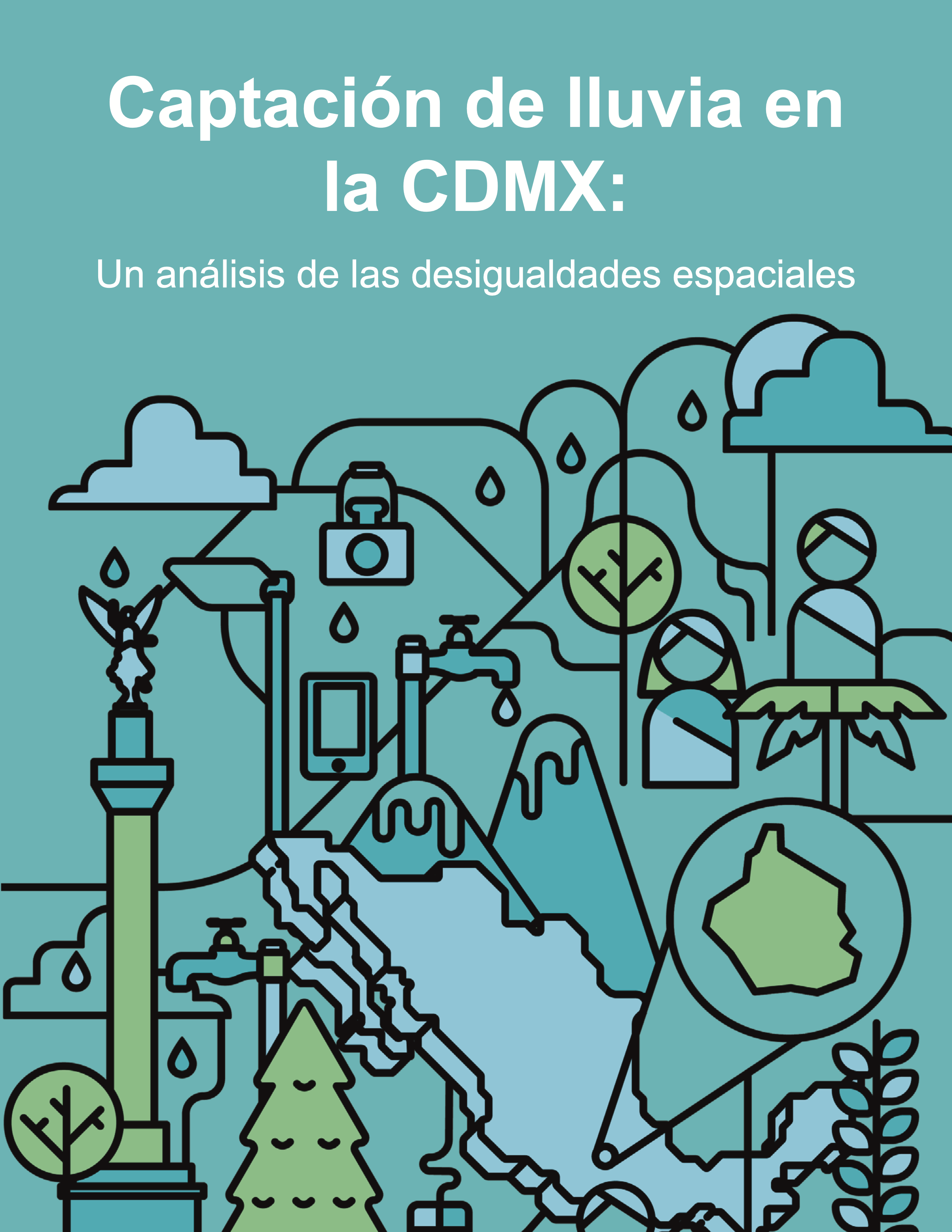 As megacities grow, infrastructure choices may either reduce or further entrench vulnerability to water security. One decentralized adaptation to water stress is household rainwater harvesting, which can improve water access in the rainy season.
We worked with Isla Urbana, an NGO in Mexico City, to estimate how their harvesting system could improve water security across the city if implemented on every home. Oxfam funded a study for us to build a large geospatial model
to integrate satellite imagery, census data, climate data, and surveys to identify the neighborhoods where rainwater harvesting systems would reduce water stress and how many systems should be installed. The study was
the basis for the city government's plan to install 100,000 systems where we indicate they could most improve water access.
As megacities grow, infrastructure choices may either reduce or further entrench vulnerability to water security. One decentralized adaptation to water stress is household rainwater harvesting, which can improve water access in the rainy season.
We worked with Isla Urbana, an NGO in Mexico City, to estimate how their harvesting system could improve water security across the city if implemented on every home. Oxfam funded a study for us to build a large geospatial model
to integrate satellite imagery, census data, climate data, and surveys to identify the neighborhoods where rainwater harvesting systems would reduce water stress and how many systems should be installed. The study was
the basis for the city government's plan to install 100,000 systems where we indicate they could most improve water access.
Key papers:
Opportunities for natural infrastructure to improve urban water security in Latin America
Selected media:
Study Paves Way for Rainwater Harvesting in Mexico City: Earth Institute, Columbia University Viven 38 mil en precariedad hídrica alta en CDMX: La Reforma Presentación de la investigación: Captación de lluvia en la CDMX: with Isla Urbana and Oxfam Seminario Captación y aprovechamiento de agua de lluvia y desigualdad espacial en la Ciudad de México con WATERLAT-GOBACIT.
Flood mapping with Floodbase
![]() I am the Chief Science Officer and Co-founder of Floodbase, a public benefit corporation which leverages remote sensing and artificial intelligence to build flood mapping and monitoring systems for governments and insurance companies. I oversee the science team to map flood exposure, risk, and social vulnerability. Floodbase was named a Bloomberg New Economy Catalyst in 2023. Recent programs include a first-of-its-kind parametric flood insurance program for California municipalities against atmospheric river flooding, and coverage for CEI’s nationwide property portfolio in Italy. My passion for reducing flood vulnerability comes from working in flood relief and resilience efforts in El Salvador from 2009-2012.
I am the Chief Science Officer and Co-founder of Floodbase, a public benefit corporation which leverages remote sensing and artificial intelligence to build flood mapping and monitoring systems for governments and insurance companies. I oversee the science team to map flood exposure, risk, and social vulnerability. Floodbase was named a Bloomberg New Economy Catalyst in 2023. Recent programs include a first-of-its-kind parametric flood insurance program for California municipalities against atmospheric river flooding, and coverage for CEI’s nationwide property portfolio in Italy. My passion for reducing flood vulnerability comes from working in flood relief and resilience efforts in El Salvador from 2009-2012.
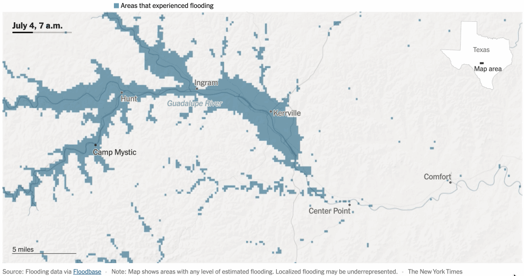 NYT interactive map of Texas Guadalupe River flooding, powered by Floodbase hourly data (July 2025)
Key papers:
Satellite Imaging Reveals Increased Proportion of Population Exposed to Floods
Comparing earth observation and inundation models to map flood hazards
Rapid Inundation Mapping Using the US National Water Model, Satellite Observations, and a Convolutional Neural Network. Frame, Nair, Sunkara et al. incl. Tellman. Geophysical Research Letters, 2024.
Selected media:
Tens of millions of people have been moving into flood zones, satellite imagery shows at Washington Post, Aug 2021; Conversation with practitioners (insurance, humanitarian, and adaptation) re: how they use satellite data and their needs for adaptation (w/ Simon Young, Willis, Saleem Huq, ICCCAD, and Jean-Martin Bauer, UN: Andy Revkin's Sustain What Podcast; A Climate Startup Aims to Narrow the Flood-Protection Gap With Data Bloomberg Jan 2023 ; “Floodwaters moved faster than Niagara Falls” — New York Times cover story on Texas flooding using Floodbase hourly mapping: New York Times, July 2025
Transformation in action: Umbela Mexico
![]()
Umbela is a non-profit collective founded in 2020, based in Mexico City and co-founded by 6 women from Mexico, Venezuela, and the US, including Beth. Umbela fosters transformation of the planet towards sustainability through innovative processes that generate spaces of collaboration to articulate diverse knowledges, cultures, and foci that contribute to well-being, justice, and equality in society and the environment. Visit umbela.org to learn more.